Here is Molly and I’s something happened here responses for our postcard memory. One challenge that I had when completing the questions was reading cursive and trying to find answers for some of the questions! One thing I really enjoyed this task because of all the things I learnt and it was really awesome working with a friend.
We are learning that people adapted their technologies and tools to the new environment in New Zealand. WE also learnt that individuals and community have responded to international conflicts in a range of ways for a range of reasons. Maori cared for and transformed te taiao, and expressed their connection to place by naming the land and its features. Aotearoa’s participation international conflicts over times reflects our countries changing view of out place in the world and our identity.
SOMETHING HAPPENED HERE
School Kit
Memory
——————————————
Photo Reading For The Postcard
- River and creeks
- Trees and shrubs
- River bed with sand
- Farmland
- Fencepost?
- Birds or fish over/in river
- Architectural photo
Clues for the artifact
- Waitaki
- In 1915 Tieke meets a historian James Herries Beattie
- This mokihi was in possession of Edward John Robertson who lived in Glenavy and ended up donating the mokihi the the Otago Settlers Museum
- WE FOUND OUR ARTIFACT IT IS TIEKE’S LIST
Task 1: Travel By Mokihi YR 4-6
- Examine the mokihi in the picture
READING THE PICTURE
- Made out of raupo
- Tied together well with straw rope or something like that
- Looks like it is made in 2 parts the rim of where you sit and the boat itself
- Rope going down the middle maybe moving the boat side to side using fin?
- Long shape looks pretty fast
- Light beige colour with lighter and dark parts
- No added paint or details
- Long part out front of the boat
- Architectural Picture
- Watch Mokihi (See how it is made and floats)
- Made with DRIED raupo
- Combe like holes in the center of the pant this enables the boat to be more buoyant.
- Search paper past then list the rivers that mokihi are used on
The rivers they are used on are
- Taramakau
- Waitaki
- Rakaia
- Rangitata
- Use google maps and mark the rivers where mokihi were used
Rangitata River

Rakaia River

Waitaki River
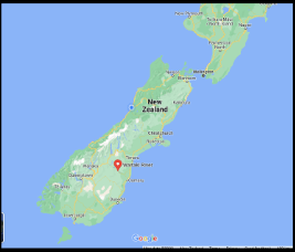 Taramakau River

- Use Kā Huru Manu – find the lakes that Tieke journeys to each year. What is in the way that would not have been there in Tieke’s day?
The lakes that he traveled to every year are:
- Ōhau
- Takapo
- Pūkaki
These days on the Ōhau lake on the rivers leading into it there are 3 new dams that you can’t get past using a boat.
Task 2: Navigate The Waitaki YR 7-8
Find the journal pages Tieke gave to Beattie in your School Kit. Note the red dots against some of the names.
Places with red dots
- Punaamaru (Old kaika)
- Teawarnako (Creek)
- Tekoa Kaumu (Love up above)
- Temareuherwa (River)
- Tewaikoura (Creek above)
- Otekaieke (River)
- Oteāke (River)
- Te Awakino (River)
- Te Awakino ( ….. gully)
- Te awauhakamau (Next creek)
- Te Warokuri
- Tepohoate Rangi Tāmau
- Ahuriri (River)
- Ohau (Lake)
- Te rua Taniwha (Ben ohau)
- Look at a google map of the area. Can you see any of the names with a red dot against them on the map?
We found:
- Otekaieke
- Te rua Taniwha (Ben Ohau)
- Ohau (Lake)
- Ahuriri (River)
- Use Kā Huru Manu to identify the Māori place names along the north bank of the Waitaki River from Tieke Pukurākau’s journals.
The places we found on the north bank are:
- Te rua taniwha (Ben ohau)
- Ohau (Lake)
- The map contains a stream labelled Te Awamoko. Who is Te Awamoko to Ngāi Tahu?
Te Awamoko was an ancestor of the Ārai -te-uru waka that capsized near Shag Point on the Otago coastline. After capsizing lots of the passengers went onto the shore to look at the land. They needed to be back at their waka by daylight. Many passengers didn’t make it, including Te Awamoko.
- Kā Huru Manu holds the names and histories of places from before Pākēha people came to Aotearoa. Why is it important to have a map like Kā Huru Manu?
It is very important that we have a map like Kā Huru Manu because it provides the NZ places history to people. If we did not have a map like this then people would not know many significant pieces of history from NZ. This map is such an Use Kareao to find Te Huruhuru’s Map.awesome way to learn more of NZ history. It also has great photos of the places 🙂 !!!!
- Te Huruhuru provided Shortland with the first maps of lakes Wānaka, Hāwea and Whakatipu Waimāori (Wakatipu).
- Use Kareao to find Te Huruhuru’s Map.

Task 3: Understand the impact
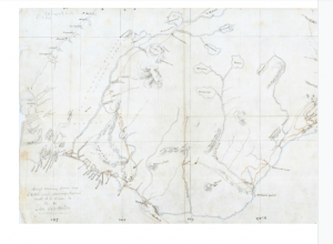
- Te Wharekōrari had an intimate knowledge of the Waitaki Valley, and drew Mantell six maps of the Waitaki River and the lakes of Te Manahuna. Examine Te Wharekōrari’s Map in Kareao.
- Use Kareao to find Mantell’s Red Map.
We think this is his red map